CU GeoData Uses Novel Instruments to Understand the World
The Department of Earth and Atmospheric Sciences is now home to one of Cornell’s newest student project teams. CU GeoData, which got its start in 2020, has close to 30 members.
Student Project Teams are a big part of the Cornell experience for many undergraduates--there are 34 official teams with more than 1,400 student participants from across the university. But it has only been in the past couple of years that one of these teams is situated firmly in EAS.
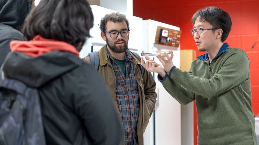
While many project teams focus on a competition of some sort, CU GeoData is different. And the difference is intentional. David Hysell--former chair of EAS and currently the Thomas R. Briggs Professor in Engineering—was there at the start. “Prior to 2020 I was chair of the department and at the time I identified the lack of an EAS-specific project team as a real shortcoming,” Hysell said. “It was clear to me that project teams are enormously valuable opportunities for students, so I started the process of creating a new team.”
Hysell understood that much of what EAS students learn does not really lend itself to building a machine that will then compete against other schools’ teams. His idea for the team was to give students a chance to apply what they were learning by building their own instruments and then using those instruments to gather data to help them better understand the world.
The process of starting a project team involved finding seed funding, recruiting a few students to become the nucleus, and agreeing on a purpose for the team--all of which happened fairly quickly. The founding group of eight students have all graduated, but Sam Jurado ‘23--one of their first recruits--had the honor of being the Primary Team Lead in the 2022-23 school year.
Jurado credits CU GeoData for helping him decide to major in atmospheric science. “I was initially a mechanical engineer, but I did not want to spend the rest of my life just doing CAD,” Jurado said. “I wanted there to be a greater purpose behind what I was doing, and I really liked the earth sciences. CU GeoData gave me an opportunity to combine novel instrumentation and engineering and design with earth and atmospheric sciences in a way that could benefit faculty research as well as the larger community.”
Jurado affiliated as an atmospheric sciences major and never looked back, staying with CU GeoData until his graduation in May 2023.
A major theme of the CU GeoData team is integrating engineering into the fields of earth and atmospheric sciences. Students develop and deploy novel instrumentation to record atmospheric, geologic and hydrologic variables. In service to this mission there are six sub-teams. The Data, Tech, and Business Teams provide support and services to the Rock, Water, and Air Teams by raising money, analyzing collected data and working on the sensors and technology needed by these teams to gather their data to begin with.
Actual team operations are less rigidly structured than this cut-and-dried description implies, with many students active on more than one subteam and with the Tech Team and Data Team more fully defining their roles over time.
A sampling of some current CU GeoData projects makes it clear that David Hysell was onto something when he thought there might be a need for an EAS-based project team. Members are currently working on the activities listed below, in many cases making their own sensors and equipment to gather the data they need:
Monitoring air quality in the Finger Lakes Region
Constructing and using a tethersonde to obtain atmospheric measurements
Placing new weather stations around Cayuga Lake
Measuring phosphorus infiltration in the local soil
Measuring soil moisture content
Creating a hydroelectric demonstration for the Cayuga Nature Center
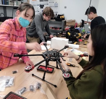
Building a drone (and the radar device it will carry) to create detailed topographic maps of the region
In addition to a busy and successful year of project work, Business Team Lead Conor Mervyn ’23 reports success in fundraising as well: a member of the EAS Advisory Council, Bruce Bailey, gave the team its first donation in the past academic year.
During a recent conversation with CU GeoData’s student leadership and Hysell it was clear that the team has accomplished much in its first three years and is well-positioned to hit the ground (and air and water) running in the fall of 2023, when they will be recruiting new members and looking for more financial support.
Hannah Lang ’18 has never been a rock collector and would definitely not refer to herself as a “rock nerd,” (though some of her good friends are). Yet, she graduated from Cornell EAS with a BA in the...
Read more about EAS alum is using data to improve mining practices


 Hysell understood that much of what EAS students learn does not really lend itself to building a machine that will then compete against other schools’ teams. His idea for the team was to give students a chance to apply what they were learning by building their own instruments and then using those instruments to gather data to help them better understand the world.
 A major theme of the CU GeoData team is integrating engineering into the fields of earth and atmospheric sciences. Students develop and deploy novel instrumentation to record atmospheric, geologic and hydrologic variables. In service to this mission there are six sub-teams. The Data, Tech, and Business Teams provide support and services to the Rock, Water, and Air Teams by raising money, analyzing collected data and working on the sensors and technology needed by these teams to gather their data to begin with.